This page is going to be dedicated to the history of Calverhall Village. I am hoping to get much support in this area from those of you who have lived in Calverhall all of your lives. I would like to fill this page full of your pictures and stories of days gone by.
What am i looking for??
> Old farming photos.
> Old Cloverly School photos and lists of people who attended.
> Pictures and stories of the village during the wars.
> Pictures and information of the Cloverly Hall fire and rebuild.
> Pictures and information about the refurbishment of the church bells at Holy Trinity.
> Points of historic interest within the village/estate.
I have made a start on this myself and so far have found the following

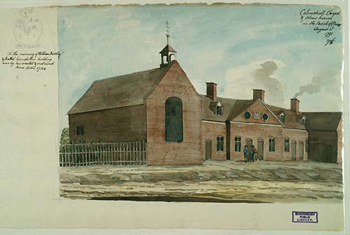
This watercolour was painted by Rev. Williams on 2nd August 1791. Calverhall or Corra Chapel, was rebuilt in 1879. The cost of the new church was paid for by Mrs Heywood, so that the church would be a memorial to her husband, John Pemberton Heywood who died on 9th May 1877.
This field was once the scene of a small but thriving village at Calverhall. The earthworks visible in the field are quite confusing to interpret. However, they appear to consist of a large curving holloway (or trackway) with a series of raised house platforms on either side. The settlement would have been populated during the medieval period (1066 - 1547) and may have been abandoned for a number of reasons. People often believe the Black Death of A.D. 1350 was the main cause for village desertion. However, it is more likely that that greedy landowners forced villages out so that the land could be reused for sheep farming.
This medieval (1066 - 1547) moat surrounds a rectangular island at Calverhall in Ightfield near Whitchurch. Although there are no surviving visible buildings on the island this was probably the site of a medieval manor house. Around 6,000 moated sites are known in England. The majority of those that have been excavated served as prestigious houses for the rich and wealthy. The moat was for display, used more as a status symbol rather than defence. Most medieval moated sites were built between A.D. 1250 and 1350.

This image is of the north window of the chancel in Corra Church. The window is in loving memory of Anna Maria Heywood. Corra is actually another name for the parish of Calverhall, which is to the north of Shrewsbury, near Prees. The Heywood family presented the church with several stained glass windows, one of which was this one presented in 1888.
The trace of a possible medieval (1066 - 1547) moated site has been identified in this field at Corra Common, Ightfield. The moat has been badly damaged by ploughing but the site appears to be small and rectangular in shape, the island measuring just 23 meters long and 16 meters wide. It would once have contained a house and other domestic buildings of a wealthy family. A fishpond has also been identified at the site and this would have been used to store and rear fish for the kitchen.
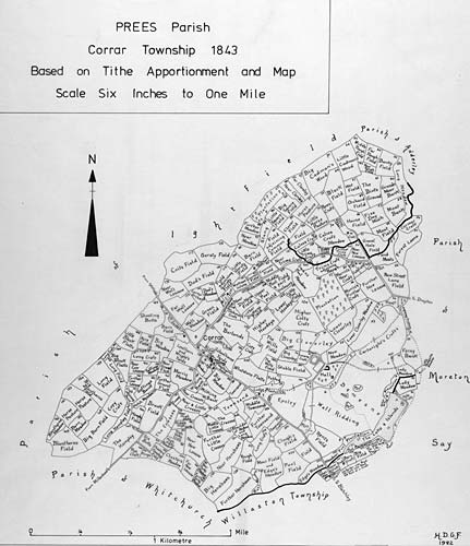
This map records field names within the Township of Corrar in Prees Parish. It is based on historical records and maps drawn up in 1843. Field names are an invaluable source of information for historians, geographers and archaeologists alike. They can be used to suggest who owned the land and how it may have been used in the past. This map was compiled by Mr George Foxall. Starting in 1961 he worked for over a quarter of a century to produce some 500 maps covering the county of Shropshire. They are held at Shropshire Archives in Shrewsbury.

This watercolour was painted by Rev. Williams on 2nd August 1791 . The church of St. John the Baptist in Ightfield is and 15th centuries. However, the church was largely rebuilt during the 1860s
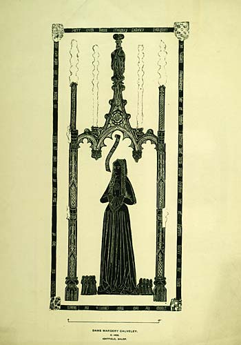
This is a representation of a brass figure that sits in Ightfield church. It is thought to date from around 1495 and is about 3ft and 6 inches long. Most of the church itself dates from the 14th century, although it was largely rebuilt in the 19th century.
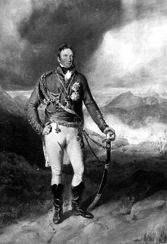
This is the first Viscount Hill. Rowland Hill was born at Prees Hall on 11th August 1772 . He went to school at Ightfield and Chester and joined the 38th Foot Regiment in 1790. In 1791 he was transferred to the 53rd Shropshire Regiment of foot. He eventually went on to become Commander in Chief of the Army when the Duke of Wellington became Prime Minister in 1828.
Shavington Hall. Photograph from Leach's County Seats of Shropshire 1891
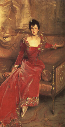
Mrs. Hugh Hammersley (Mary Frances Grant, 1863-1911), painted in 1892 by John Singer Sargent. This painting is in the Brooklyn Museum, New York.
She was the daughter of General Owen Edward Grant and Adelaide Higginson. Adelaide Higginson was the daughter of General George Powell Higginson, Grenadier Guards, Col. of the 94th Regiment*, who carried the Regimental Colours of the Grenadier Guards at the Battle of Corunna (1809), by his wife Lady Frances Elizabeth Needham (d. 1890), daughter of the 1st Earl of Kilmorey (who fought at the Battle of Bunker Hill in 1775) seated at Shavington Hall (or Park), nr. Market Drayton, Shropshire, which was demolished in 1958
Lonsdale (Canada) • This part of North Vancouver is named after Arthur Heywood-Lonsdale of Shavington Hall, Shropshire, who with a kinsman once owned the waterfront between Moodyville and the Capilano River
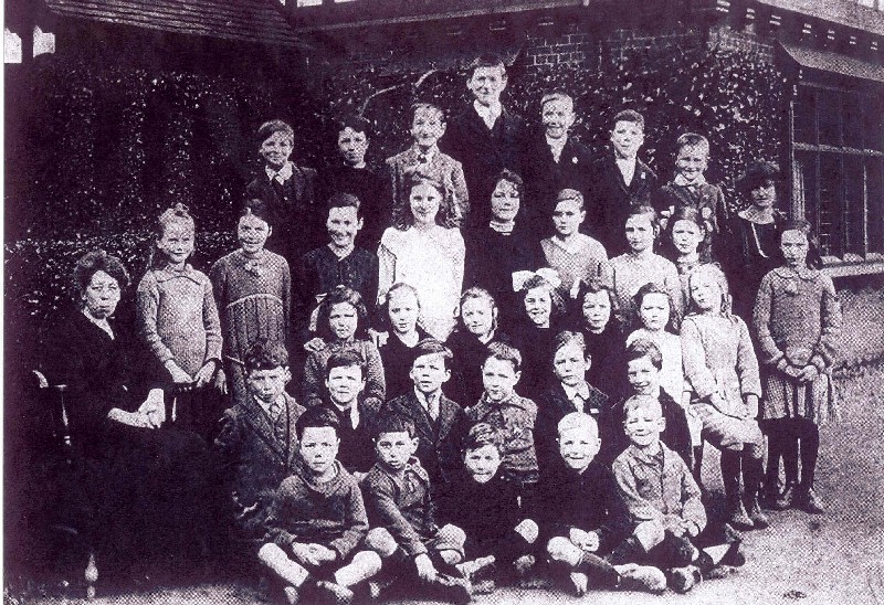
The above image is from Calverhall School taken in 1924
Back row - L Spragg, S Malam, G Worral, H Dykes, T Ridgeway, J Cadman, S Pennell, Miss Gourlay
4th row - Miss Smith, G Ridgeway, M Morris, E Cadman, W Stanley, L Pennell, G Cliff, M Charlesworth, N Dykes
3rd Row - N Bailey, M Lister, D Ward, M Cadman, E Broadbent, W Evans
2nd row - W Cadman, E Higginson, R Higginson, J Morris, G Jenkins, R Evans
Front row - P Cadman, T Price, C Perkins, C Ridgeway, H Jones.